|
|
 |
|
|
|
Fishing
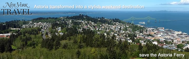
Where the Mighty Columbia River Meets the Pacific Ocean
Fishing the Columbia River for fall run salmon is excellent. Astoria area has several coastal tributaries that offer excellent fishing opportunities - Youngs River, Lewis & Clark River.
The Columbia offers some of the best Sturgeon fishing, Walleye fishing, Coho salmon and King salmon fishing found anywhere in the World. The Coast rivers and bays offer world class angling for steelhead, salmon and crabbing.
Oregon guided trips for King salmon Coho steelhead sturgeon at Tillamook Bay Nehalem Bay Wilson Trask Hammond Warrenton, Columbia River Buoy 10 Astoria fishing guide ocean charters for halibut tuna Oregon coast, cannon beach, Lewis and Clark, Manzanita, Garibaldi and Pacific Northwest.

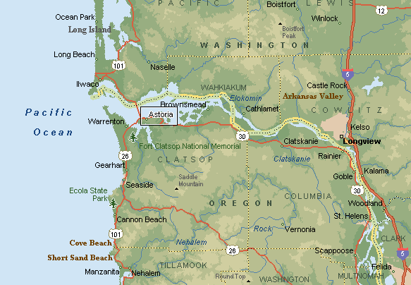
The Exceptional Buoy 10 fishery just west of Astoria will give up easy limits of salmon during the peak run in August and September.
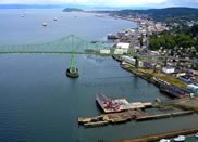
Lower Columbia (Buoy 10) Salmon Fishery
The following Buoy 10 Fisher Information is sourced and contributed by:
Visit their website here.
First things first - when & where you can fish:
It is common for WDFW & ODFW to open this fishery August 1st & close it near Labor Day, but the closure is very dependant on the projected run, quota set & the actual total catch. The best fishing does not usually start on the opener, but picks up within a week or two, depending on the weather.
There is a agreement between the two states called shared jurisdiction. What this means is that a Washington angler can fish in a BOAT in Oregon waters, & the other way around. You can also launch on either shore & fish, with either license. HOWEVER, you CANNOT bank fish on a shore that you are NOT licensed for.
Washington & now Oregon have fishing regulations in effect on the river as described by the new Oregon regulations. "Each angler aboard a vessel may continue to use angler gear until the daily limit of fish for all legally licensed & juvenile anglers aboard has been achieved. However no individual angler may exceed any personal daily bag limit."
Weather Conditions:
The weather here can at times be windy & therefore choppy enough that the average small boater should be very observant. If you are on the middle of the river & the wind comes up, it will behoove you to move closer to your launch point before it gets dangerously rough.
The wind typically picks up between 1:00 & 3:00pm and there WILL be chop on the water when you head back if you launch at any of the first two launches listed below. With a smaller or an open boat you WILL get wet. This wind usually dies down later in the evening, usually around 7:00pm. A deep 16' boat would be considered minimal, and it should be mandatory that an operational bilge pump and a fully functioning kicker motor be attached & ready. A convertable top can be a lot of help if you are running with any chop on the water.
Water Conditions:
This is a large river with LOTS of water moving during any exchange. A small skipper miscalculation or innattention for a moment could be deadly. It is prudent to have all on board wear a Personal Floatation Device. The new suspender inflatable type are becoming more popular since the Coast Guard has now approved them, (if being worn).
Commercial Vessel Traffic:
One thing to keep in mind is that this whole river is a means of commercial water travel for many different types of vessels, including ocean going ships & tugs. The normal shipping lane depths may be dredged & kept at a minimum of 40ft. The ships will be coming in at any time of tide but upriver & downriver traffic can increase during the high tide. These shipping lanes are just like a highway, with upriver designated for the Oregon side, & downriver designated for the Washington side of the lane. If you as a small boater plan on fishing & or anchoring near these shipping lanes, it may be a good idea to become familiar with the US Coast Guard "Rules of the Road" as far as who has right of way & the boat whistles governing them.
Method of Fishing:
Most of this salmon fishing will be trolling a cut-plug herring off a diver trolled with from 25' to 40' of line out. The use of a Fish Flash no-drag flasher has now become widespread. When using it behind a diver, you may need to tie a short length of line (12") between the diver & the Fish Flash to allow it to get out of the diver's turbulence so that the Flash will rotate properly. An Apex plug in chrome, blue prism/chrome or a Coyote spoon in cop car, or glo in the dark green/white can also be very productive here using the diver, or off a downrigger if you are fishing an area that is out of the heavy concentration of boats. Mooching a cut-plug herring is of course another viable method practiced by some.
Where to fish:
Close to Buoy 10 can be called "Combat Fishery", meaning the boats will be maneuvering, trolling/mooching in close proximity to each other, & some boat operators do not watch where they are going. Charter boats seem to tend to squeeze the sport boats, with their rods almost touching the smaller boats. Other boaters may seem to not be aware of what is going on around them, as when a big fish is being played within 20' of their boat. This can be compared to a large dance with MOST of the boats all hopefully going the same large circle & close to each other. Occasionally a blind operator may want to troll across thru the trollers or a mooching dance floor, which may even get more than under the breath exclamations toward him. It is not uncommon to look out & see 300+ boats in an area of 1/2 mile. One thing, if anyone fell overboard, they would not be in the water over a few minutes.
Most salmon fishing early in the season will be near Buoy 10 at low incoming tide, some prefer just north while others prefer south of the buoy. When fishing for Chinook early in the season, a trend is to be at the buoy at low incoming tide & allow the tide to carry you upriver along the Oregon side, sliding across & over to the Washington side just above Chinook. There seem to be good bait holding spots off the breakwater piling on the Washington side near both Big & Little Sand Islands on the high ebb.
When the Coho are in, they of course will be intercepted first at the buoy "Firing Line", then they follow a rip upriver as the tide comes in. Later on in the tide & or season, the fish seem to congregate near the northern end of the Astoria/Megler bridge.
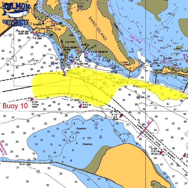
The worst, as far as concentration of boats, will be near Buoy #10, which is the westernmost WDFW /ODFW boundary & the first shot at these returning fish. It seems to be human nature to be there at the starting gates when the gun goes off. The jetties' shore ends, would be about between buoy #11 on the north & buoy #12 on the south. Buoy #10 is located about 1 mile outside or west of these two buoys. This area, however, seems to be one of the best locations to fill a limit. Most of the charter boats will work this area.
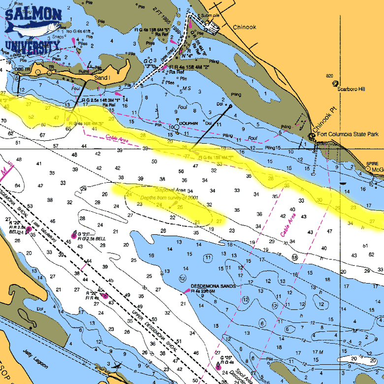
Many people will bypass the buoy & fish upriver near the middle of the river and near where the the "Yellow Can" (D) buoy, N46°14'40" W123°57'30", used to be, (they have removed it in the last couple of years). It still shows on some older charts, which designates a dredge dumping area and is in 25-30'. It is about 1/2 mile off the breakwater near the town of Chinook entrance.
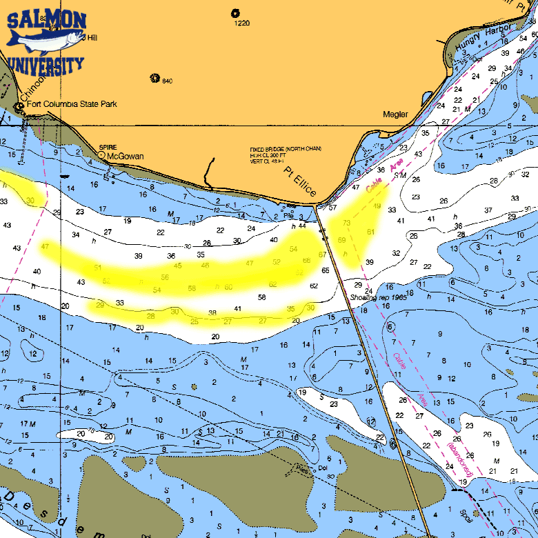
There is also a 50'/60' slot at the "Church Hole" which is between the Chinook entrance & upriver to the bridge on the Washington side, where many chinook salmon are taken. There is a old church on the Washington shore that is right on the shore & its steeple is very visible, hence the name. The charts may only say "Spire" on the shore in this location. The other area where many fish are taken is again from the church to the bridge but farther away from shore in the 30' slot. As the tide nears & goes into high slack, the fish then seem to congregate above the bridge & up to the WDOT rest area. This area near the Washington shore has also been called the "Blind Channel."
Some nice chinook have been pulled by back bouncing a herring along the bottom thru this Church Hole slot on an outgoing tide.
There seems to be an imaginary line from the Washington side high spanned section of the bridge to Tongue Point that the upriver salmon seem to follow and cross over the shallows at high tide to the main channel on the Oregon side. The few that stay near the Washington shore in the upper end of the bay, will probably be Deep River or Grays River fish. The river's deeper channel splits at about the Chinook entrance. It is wide & deep enough at this area that many fishermen do not realize this split takes place. The main shipping channel follows the Oregon shore up past Astoria, Tongue Point & on east of Rice Island & then onward toward Cathlamet. The center of the river below & above the bridge is dotted with sand spits at low tide. The deeper water on the Washington side terminates above the bridge just above the WDOT rest area. This channelis sometimes called the "Blind Channel". This shallower channel then runs upriver toward Portuguese Point & then on into the mouth of Deep River & Grays River.
The water temperature recorded at Bonneville Dam this time of the year usually will be 70 to 72 degrees, but on the incoming tide at Illwaco, the cooler (56 degree) ocean water will come in & back upriver on the high tide, cooling the river water to below 60. As the tide turns and starts running back out the temperature will raise to about 62-65 degrees. Once the fish move above this cooler water where there isn't the cooler salt mix, this is really warmer for them to comfortably stay in. So the early fall chinook above this estuary will more than likely then be found in the deeper holes or at the mouths of the rivers dumping into the Columbia.
Boat launches in the area:
There are many launches on both the Washington & Oregon side of the river in this vacinity.
Illwaco: Port of Illwaco 165 Howerton Ave., Illwaco, WA 98624, 360-642-3143, $5.00
Fort Canby (State Park) $5.00
Chinook: Port of Chinook, 1 Portland St., Chinook, WA 98614, 360-777-8797, $5.00
Deep River: Eva's Bait & Tackle, 121 Onieda Rd., Naselle, WA 98638, 360-465-2582, $5.00
Cathlamet: Elochoman Marina, P.O. Box 651, Cathlamet, WA 98612, 360-795-3501, $3.00
Hammond: Hammond Marina, 1099 Iredale St., Hammond, OR 97121, 503-861-319, $5.00, with a parking fee of $5.00
Warrenton: Warrenton Marina, 550 NE Harbor Pl., Warrenton, OR 97146, 503-861-3822, harbormaster's cell 503-791-1925, launch fee $5.00
Skipanon Marina: Skipanon Marina, 200 NE Skipanon Drive, Warrenton, OR 97146, 503-861-0362
Youngs Bay Yacht Club: Youngs Bay Park, Astoria, OR, 503-325-7275, free
John Day River, (Tongue Pt., county launch), $3.00
The launch at Illwaco is off the main road into town just after you drop down off the hill, take a left at the sign that says launching ramp. If you miss that, then just go to the stop light, turn left and the frontage road at the dock area, follow it to the eastern end & around the boat basin to the launch on the southeast side. There is a nice new two lane ramp, also a sling, & with lots of paved parking.
For Fort Canby, you have to go east thru the town of Illwaco, at the stop light, west & south & then back east, winding thru the park then down to the ramp. The State Parks Dept. is planning to improve this launch in the early summer of 2003. The plans are to install a 3rd lane & to increase parking.
The Chinook launch is off Portland Street. It has a new concrete ramp and a sling, but parking is limited & the overflow is along the streets. Also the channel out of the Chinook harbor is narrow & somewhat winding on a LOW tide. There are however small hemlock poles pushed into the edge of the channel.
Bait:
Bait is available at both Illwaco or Chinook thru Ed's bait. The Illwaco location is open at 5:00am & is on a dock that is close to the launch area. The Chinook location is out of a small grocery store on the west side of the main road north of the launch road. It is the Chinook Country Store, phone 360-777-2248, you can call ahead before closing time which is around 7:30pm & reserve bait for the next day.
The other alternative is Deep River.
It takes about 30 minutes for the average boat to run from this launch downriver to the Astoria bridge. This launch is located off State Highway 4 between Naselle & Cathlamet. If you are coming from Longview on Highway 4, you would go thru Cathlamet, Skamokawa, up over a large hill, & there is a community called Rosburg. The next river you cross will be Deep River, this is a low concrete bridge. This is 25 miles from Cathlamet. TAKE A LEFT AT THE WEST END OF THE BRIDGE ONTO ONIEDA RD.
The pay/bait shack is on the top of a hill a couple of miles south of the highway & before you get to the ramp area. Launch fee is $5 and camping is $10, or $13 with power. Eva, the lady that runs it, makes a trip to Chinook every morning & has fresh bait at about 5:30am during the season. This is a private blacktop ramp, small loading dock, & a reasonable parking lot. But a large mowed field behind the dike road is an overflow lot of about 5 acres with room for dry camping. This launch is popular with sturgeon fishermen as well as salmon fishermen & this time of the year you may have to wait to launch or load at the prime times. There is not enough dock area (only 2 to 3 boats) to tie up to & then only for launching & loading purposes. You would have to load your boat back on the trailer if you were going to stay overnight. They do not allow power loading because the rock off the end of the ramp can be washed out. There are Sanicans for restrooms here. A fish cleaning station is also provided.
The one drawback here is at a LOW minus tide, the channel as you enter the bay is navigable, but narrow by some standards. There are three deadhead logs that have one end floating, but they appear to not be submerged at high tide & are always showing. One is near #16 in the center of the channel & the others are between Rocky Pt & Portuguese Point in more open water. The piling markers for the Deep River channel seem to use their own numbers, & after you get in the bay some of these numbers may be repeated.
When you run out of the river from the launch & enter the bay you need to follow the piling markers close, stay on the right hand side going out, water depth will be between 6' & 9' on a normal low tide. These markers are all within sight of each other (150 yds) unless you get fog, which may be occasionally in the mornings. The 1st piling out will be #16, then #14, & then #12. From here you start into a right hand corner to #10. Between #10 & #8 is where it is sanded in. If you swing toward the RH shore from #12 to loop around #10, then toward #8, staying to its right, you will be in deep enough water to travel. Now from here you can follow the RH shore piling on down to Rocky Point. Do not hold tight to the shore marker here, as it sits on a rock outcropping near shore. Make another right hand corner beyond the point & head Southwest for about 500yd to within 100yd of that shore. You will turn to the left & head South keeping the shore on your right, heading toward but keeping west of piling marker #14A, which is about 150 yards off the shore.
GPS readings for the marker piling for the Deep River channel are as follows:
#16 46°18'58"N 123°42'61"W
#14 46°18'36"N 123°42'56"W
#12 46°18'13"N 123°42'62"W
#8 46°17'31"N 123°43'62"W
The point of land here is Portuguese Point, a flat grassy area with the #14A off shore on one side & #13 around the corner next to the shore. A different piling marker #12 is out away from the shore & downstream. Around here is where some sturgeon fishing usually takes place. There is a 90' hole off the point, most sturgeon are not caught in the hole, but around the edges of it, or into the 14A channel & then down to the #12 piling. From Portuguese Point, you can see the Astoria bridge, to run to the bridge, head to the north end of it, keeping the WA shore on your right & don't expect to approach anywhere near the center of the river or cross over if you are using a prop driven boat. Later when the DFW closes the Buoy 10 area, you will have to fish above Rocky Point on the Washington side to Tongue Point on the Oregon side. The middle of the river above & below the Astoria bridge gets shallow & changes yearly, & at a LOW tide it may have much sand showing, so it is not really practical expect to cross over to fish the main channel above Tongue Point from the Deep River side with a prop boat. Therefore it might be best at that time to launch at Tongue Point or at Cathlamet & run downriver. The one good thing about this upper area is that if you use it to fish down to, or below the bridge, WHEN the wind picks up in the afternoon below the bridge, you can then slide back upriver toward the launch without bucking any rough water. And as you head back upriver above the bridge the water conditions usually lessen. Then from Portuguese Point to Rocky Point you can drop in & fish for sturgeon if the season is open.
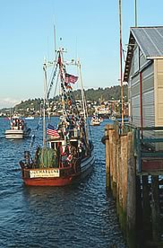
Fishing for salmon, sturgeon, or bottom fish will find charter boats in Astoria, Warrenton and Hammond. The experienced charter operators can take care of everything, including fishing licenses.
Fall Chinook Salmon
Lower Columbia River:
Fishing the Columbia River near Astoria is the most productive salmon fishery in the state, with fish running 10 - 50 pounds. Limits are very common here.
About Salmon
Pacific Salmon:
Salmon found in the North Pacific Ocean spawn only once, dying after depositing and fertilizing their eggs. The best-known and most valuable species is the chinook salmon, which is also known as the king salmon, Columbia River salmon, quinnat, chowichee, and takou. Market specimens of this fish average about 9 kg (about 20 lb) in weight, but numerous specimens more than 1.5 m (more than 5 ft) in length and well over 45 kg (more than 100 lb) in weight have been recorded. The chinook salmon migrates farther than any other salmon, often traveling 1600 to 3200 km (1000 to 2000 mi) inland to its spawning ground. Its eggs usually hatch within two months, and the young descend to the sea when 5 to 7.5 cm (2 to 3 in) long. The sockeye, red, or blueblack salmon is another valuable species, as is the coho, or silver salmon, which has light pink flesh. Other salmon in the Pacific basin are commonly known as the pink, or humpbacked salmon, and the chum, or dog salmon.
Anglers fish for salmon with rod and reel, often using flies as bait. Commercial fishing for salmon is done on a much larger scale, employing traps and pound nets to catch the fish on the way to their spawning grounds. Salmon canning is one of the major industries of the American Pacific coast. To mitigate the decimation of wild salmon runs caused by construction of dams and overfishing, the U.S. Fish and Wildlife Service yearly deposits billions of salmon eggs and young, propagated in nurseries, into natural breeding grounds and constructs fish ladders for the upstream journey of mature salmon. However, hatchery-raised salmon have aggressive feeding habits-that is, they spend most of their time at the water's surface looking for food unlike the wild salmon that spend most of their time in deep water or under cover. As a result, hatchery-raised salmon consume most of the food wild salmon need to live. At the same time, this aggressive feeding makes hatchery salmon more vulnerable to predators because they stay near the surface. Hatchery salmon usually have less genetic diversity (see Genetics: Genes in Populations) than wild salmon, which can lead to lowered resistance to disease and other environmental hazards. The annual harvest of wild and farm-raised salmon in the United States averages about 478,000 metric tons, of which about 60 percent is canned.
Technical Stuff
Scientific classification: Salmon belong to the family Salmonidae. The Atlantic salmon is classified as Salmo salar. Pacific salmon belong to the genus Oncorhynchus. The chinook salmon is classified as Oncorhynchus tshawytscha, the sockeye salmon as Oncorhynchus nerka, and the coho salmon as Oncorhynchus kisutch.
Sturgeon Fishing
Season January thru July.
Sturgeon fishing on the Columbia river in Astoria Oregon - Best Months: May, June, July
"The lower Columbia River that divides Oregon and Washington States has the best Sturgeon fishing in the world. It's an experience you won't forget!
...May thru June the big oversize fish come in following the Shad.The thrill of a lifetime to get an 8' to 11' foot fish on the end of your line."
About Sturgeon
In salt water, sturgeon range from Ensanada, Mexico to the Gulf of Alaska. The larger river systems on the west coast host spawning runs. The Columbia-Williamette, the Sacramento-San Joaquin, and the Umpqua are the most notable. Smaller populations can be found in the Russian, Klamath, Rogue and Coquille systems. Populations with access to the sea may or may not migrate and there are landlocked sturgeon in the Columbia River and Shasta Lake.
Sturgeon can live to be 100 years old and are the largest fresh water fish in North America. The sportfishing record fish was caught in The Dalles, Oregon and weighed 900 pounds. All the west coast states have bracketed length requirements for fish taken. For Oregon and California fish that are 4 to 6 feet in length are allowed to be kept. Check the Regulations!
A female sturgeon takes at least 11 years to mature, males somewhat less. Sturgeon do not spawn every year. Spawning takes place during the spring and the fish prefer rocky or gravel bottoms. Up to 5,000,000 eggs are released into the river followed by the milt. The sticky eggs adhere to the bottom where they hatch within 2 weeks.
Fishing Charters
|
|
|
|
|